Search This Blog in the above block
~ I dont blog about things to be liked. I blog about things that I like ~ ... so that one day, on my death bed, I will have said and done what I wanted to do, and die peacefully without regrets.
Live your life in such a way that when your feet hit the floor in the morning, Satan shudders & says..' Oh shit....She's awake'

Tuesday, January 17, 2017

Hiking Spesbona Forest via Echo Valley Kalkbay

We were inspired by a photo from a book I got my husband for our anniversary, South Africa's Wildest Places, authored by Scott Ramsay. Even thought this hike is at the top of my list of favourite places, seeing Scott's photo of the Echo Valley Boardwalk made us realise that this is really the photo we would love to see more often.  So for a while now I have been pondering on what photo I would like as a wall mural in my office.  It had to be something inspirational and definitely a place I would like to 'go to' when you need to 'get away'... 

This is one of the places I can easy call my happy place, and Im sure many many others who have been here would agree with me.  So instead of sharing photo's like we used to in our blog posts, we decided to do a video of our experience on the walk and in search of 'the photo'.  My video skills are slightly improving and the editing... well let's just say, we are getting there ;)

Hope you enjoy the walk with us from the comfort of your computer screen.

If you wish for us to take you on this 2 hour walk, we charge R1000 minimum fee , and R250 per person if it is more than 4 people.  This can also include an epic cave walk (add another hour and R100pp), but it will depend on the weather - as you can't enter the 100m long cave shortly after the rain.  We mostly prefer to hike in the winter months due to the fact that hiking in summer heat and the potential danger of high risk  during the summer fire season.  It will be a memory lingering for a long time after your visit to this beautiful part of Table Moutain.

Untill next time,
Juanita and Alex

Saturday, April 9, 2016

Hiking Half Collared King Fisher Trail in the Wilderness national park Garden Route

Wow, its been a while since I last blogged, but hey, starting an online magazine and having a precious little baby and life then happens, blogging kinda falls behind a bit.  I missed writing about our hikes, but we did not stop hiking, we just did not have the time to blog our hikes.

Anyway enough excuses, and while on holiday recently in the Garden route we stumbled upon a few hikes that I wish to share with you.  Before the hike and much of its details slip my mind, I will write about our experiences of these lovely routes and hope you get to experience them too!

For now, I will discuss the Half Collared King Fisher Trail.

Accommodation: Lake Pleasant Living Holiday Resort, Sedgefield.

Comes highly recommended, especially if you are a family.  They have all the amenities one can ask for and are in close proximity to all the major attractions.  The hotel staff were so incredibly accommodating and friendly, I will have no hesitation to want to go back there.

How to get there:  
Start by going to get your permit from the Ebb and Flow Camp at the SANPARKS Wilderness national park.  Below is a geographic map to show where it is in relation to Wilderness, a copy of my FitBit calculation of distance and time to complete the route is also shown.  Park your car inside the camp or there is a small parking area just next to the railway bridge outside the camping areas.


Take careful note of the map below and you will see the 2 sections that we did not cover while on this route: 
1. We did not opt to go the BOSDUIF trail, due to time constraints we did not explore this loop.
2. When doing the Bosduif, you also have the option to cross the river at THE STEPPING STONES.


Cost:
You need to pay a fee (R15 pp) at the Wilderness National park reception.  This is where they give you a map and all the important details.  It's free if you have a Wild Card of course.
Distance:
4 km one way (8km return). Give yourself 4 hours, but nothing less, unless you plan to run it.
Difficulty:
Easy but not for an old dog.  In fact this is not a route where dogs are allowed, the boardwalks can cut their feet in the wet slippery conditions.  Its practically flat the whole way, with a very super fancy board walk to guide you in your adventure through this beautiful forest.


Exit the Ebb and Flow South Rest Camp, and turn left to walk about 100m over the single lane railway bridge over the Touw River.

Opposite the Wilderness water purification plant, you will see a sign to mark the start of this hiking route.


No need to worry too much about a map or a guide, as this route is as clear as you can get. It is however nice to have a map, because the you can always have a good understanding of your location when you get to places where the road forks, the pontoon or the waterfall.


In the beginning you walk below a shaded canopy, and a few board walks to take you over the tricky parts of the mountain.

Scenic views are around every corner.  In this photo you can still see the Ebb and Flow North Camp site on the opposite side of the river.

In the image above you can clearly see how the river meanders into the background, clearly marking the path ahead of you.


You are also able to hire a kayak (from the reception) and paddle for half of the distance to a set point in the river.  We would loved to have done this too, but we started so late (3pm!), time was not on our side.  The kayak adventure looked so stunning. Would love to come back and do this part of it just for fun.


As we walked we found many well market picnic spots along the river.


This route hugs the Touw river all the way to a waterfall.


When to go:
Most of this walk is done in the shade and on a wooden board walk.  This should give you enough information to decide whether you would like to do it in summer or winter, on a dry or rainy day. "Slippery when wet" comes to mind here ;)


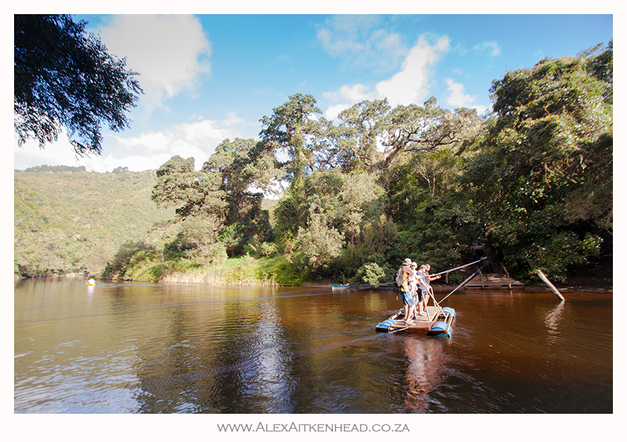
Halfway to our destination we had to cross the lovely Touw river by means of a fun pontoon.  Each to their own here.


A selfie was the order of the day while crossing the river on the pontoon !


A short distance after we crossed the pontoon, we found the Kayak-stop.  This is where the rowers parked their kayaks to continue their journey on foot to the waterfall another 2km further.


The tranquility of the river was the perfect spot for us to take a short break and enjoy the moment.  Our 2 year old son loved the cool water and 'rocks for Africa' to throw...


This well maintained board walk was an absolute pleasure, never been so spoilt for such a long distance on a hike before!


Eventually after 2 hours and 4km later, we reached the waterfall.  


From here we turned around and raced back, daylight time was not on our side as neither of us brought a Petzl with us and both of us ran out of phone battery.  Rather silly, but we did not expect this route to be as nice, and so long.  Key here is to always come prepared I guess.


Feel free to ask questions in the box below, I will be happy to help if I can.  Thanks,

As for the King Fishers... I did not hear or see any???

PS:  all these pics were happily shot from my Sony Xperia waterproof phone that I love, but there are a few beauties squeezed in that my hubby took with his brick ;)

Happy Hiking!

Wednesday, February 6, 2013

Crime on Table Mountain

Crime on Table Mountain - Important meeting to address issues

A public meeting has been organised for the Wednesday Evening, 13th February (6pm for 6.30pm) at the MCSA Club to discuss the current spate of muggings in the Table Mountain National Park.

The intention is to ask TMNP management to provide an overview of their crime fighting strategy for 2013 and to explain specifically what they have in mind for the two hotspot areas, namely Rhodes Estate / Memorial and the Sandy Bay / Karbonkelberg area.

Once this is understood by everyone the plan is to open the floor to ideas and suggestions and more specifically to ascertaining the level of willingness of TMNP to engage with mountain users who are concerned and who are expressing a willingness to assist the park in various ways.

Please try to attend, especially if the situation is of concern to you and if you have an idea of how we may engage and assist the park.

For further info. please contact Andre van Schalkwyk of the Table Mountain Safety Action Group on 082 568 6562.
MCSA Hiking Cape Town
TableMTB
Table Mountain Watch
Hikers Network

Monday, January 14, 2013

17 hikers airlifted to safety at Hout Bay yesterday

The hiking route between Houtbay and Sandy Bay is not for the faint hearted.  This is the kind of route you take when you are hiking fit and you know where you are going.  This route is exposed with very high cliff faces, and little shelter from the elements.  Its also not obvious that this route is just over 10km long! so it will take a fit hiker nothing less than 6 hours to do.  I was fortunate enough to go on this route with Dieter Heiser who is a very well known hiking leader and we started walking at 7am.  By the time the shade had vanished, we were well over 3/4 of the route done, then from there we had to find our way by means of crawling through thick scrubb and unclear paths. 
 

Notice how exposed the people are on that rock face in the far background.

If you dont know WHERE to go, you can very easily get lost here

Sandy Bay looking back at the exposed face of the Karbonkelberg


Im glad I did this route, and would like to do it again someday.  It is with this in mind that I am sorry to hear about the unfortunate situation that took place on this route yesterday, but glad everyone is safe back at home.  

Herewith the story as it was published in a newspaper website today: St. Francis Cronicle


Seventeen hikers were airlifted to safety in Hout Bay after they got into extreme difficulties on an 8-hour hike yesterday, 13 January 2012. 

The hikers had to be hoisted in relays into the rescue helicopter and airlifted to the NSRI rescue base. Fifteen were initially airlifted, then after a search another two hikers, who had separated from the main group, were found near to the Boss 400 crane barge wreck and they were also hoisted into the rescue helicopter and airlifted to the sea rescue base.  Another four hikers from the group made it safely back to the Sandy Bay car park in Llandudno without assistance and needed no further help.

Lyall Pringle, NSRI Hout Bay station commander, said  at 3.30 pm NSRI volunteer sea rescue duty crew were placed on alert following a request for assistance from a hiking club reporting to be hiking with 21 Cape Town hikers on the Karbonkelberg Hiking Trail, between Sandy Bay and Hout Bay. The hikers were stuck at Die Braak, about half way along the trail and unable to proceed. 
Image
Photo: View of Karbonkelberg, Hout Bay Pic Source: Wikivillage.co.za

“Their guide had never hiked the trail before, they appeared to be ill equipped with some of the hikers wearing slip-slops and some hikers having no warm gear and most had inadequate water supplies. Two of the hikers were reported to be asthmatic.” 

Scores of past hikers have found themselves needing to be rescued at the De Braak junction, Pringle noted. The hikers started the hike at 8 am and at some point got lost, delaying their hike.
“The Hout Bay branch of Wilderness Search and Rescue (WSAR) and the WC Government Health EMS rescue division were notified and the EMS Skymed helicopter was placed on alert.” 
The NSRI plan was to deliver experienced rescue guides by boat to the location to assist to walk the hikers out of their predicament . Supplies of water, cool drinks, extra food and energy bars, were purchased by NSRI to deliver to the hikers.

Prior to this the Skymed rescue helicopter responded and WSAR rescuers would be deployed to the hikers by helicopter. Then a decision would be taken to either hoist the hikers into the helicopter or for the rescue guides to hike them to safety. 

“Our NSRI Hout Bay volunteer sea rescue duty crew launched our sea rescue craft Albie Matthews  and Nedbank Rescuer . On arrival on-scene two NSRI rescue swimmers swam ashore to begin to triage the hikers and our rescue swimmers took hand-held radios, for communications, plus the sea rescue vehicle was dispatched to Rocket Road, Llandudno to aid with VHF radio communications.” 

Some of the hikers had decided to return to Sandy Bay , some of the others fearing dehydration drank sea water which accelerated their dehydration while also making them feel rather unwell. 
A lone female hiker was also spotted by the rescue helicopter, hiking on the trail, but she indicated to the helicopter crew that she was in no danger and that she was happy to continue with her walk.  It was later determined that she was not part of the hiking club and we suspect that she may be a very experienced hiker on her evening walk! 

 ”No one was injured and after consuming the supplies that NSRI had purchased for them at the sea rescue base all 17 hikers left to go home,”  Pringle added.

Saturday, December 29, 2012

Go to the Wolfberg Cracks

This route comes highly recommended for those in need of a nice long-weekend away:    Try the Wolfberg Arch and Wolfberg Cracks. The perfect time to go is the end of April or September.  Book ahead of the long-weekend to ensure you can get there.


Tuesday, November 20, 2012

Activity Permits Table Mountain National Park

Recently one of our members whilst trad climbing on Lions Head was approached by a Parks Board Ranger & asked to produce his Activity Permit.

Activity Permits are not in fact required for traditional climbing. They are required for Sports Climbing but this does not apply to card-carrying MCSA members.

 If you are approached by a Parks Board Ranger & requested to produce your permit I would suggest that you politely explain the position to him and suggest that he obtain confirmation from the Park Manager Paddy Gordon.

Please pass on details of any approaches that you may receive from Parks Board Rangers to Brian Lambourne.

Also see http://www.sanparks.org/parks/table_mountain/tourism/access-cards-permits.php#permits for more information on TMNP's activity permits.
Thanks
Elizabeth
Mountain Club of South Africa - Cape Town
97 Hatfield Street, Cape Town 8001

Saturday, August 25, 2012

Trail Runners Guide South Africa

Hiking has been taken to a new level in recent years, and a very popular sport has emerged called Trail Running.   If you are into your hiking and want to take it to the next level, then Trail Running is what you should consider. Many road runners have also exchanged the hustle and bustle of the busy roads to the tranquillity of the nature and its jeep tracks and animal paths...
Jacques Marais is pro-photographer and authored numerous outdoor titles, but I would rather give him the title of extreme outdoor photographer.  He has combined his passion for photography, writing and his love for outdoor sport and put together the first edition of the Trail Runners Guide for South Africa.
 
This comprehensive book includes :
•    Trail Running Event Information
•    Trail Descriptions
•    Detailed Map of the Trail
•    Fact Panel
•    Altitude Profile
•    Great Photographs
•    An interview with an expert who has run this trail


Another lovely section in the guide is a monthly list of all the various Trail Running Events that take place around South Africa every year.  This alone will be a great way for you to plan your fun for the months ahead.  Each trail review has a listing of items to pack, where to stay and what kind of weather conditions to expect.

To add this easy to read Trail Running Guide to your library and things-to-do list, it can be purchased for R250.00 at selected bookstores around South Africa or you can get your copy online at www.mapstudio.co.za

MapStudio, the leading publisher and distributor of maps and travel guides in Africa, has just launched the Trail Runners Guide, which features 100 events and trails in detail.

South Africa offers a variety of terrain, surrounding landscapes, abundance of animal life, and weather conditions.  Trail Runners Guide is a one stop guide to training, gear, footwear, nutrition and events as well as insider tips from South Africa's leading trail running experts.

The foreword was written by ultra-runner Ryan Sandes (find him on twitter @ryansandes, From Streets to the Trails by Elana Meyer, The Minimalist Movement by Benita de Witt, The Thin Edge of the Wedge by Jen Rorrison, The End of the Pasta Party by Tim Noakes and Woman Alone by Kim Van Kets.

So get your Trail Running shoes on and start going off road for some extreme running fun.

Wednesday, July 18, 2012

Hiking Platteklip Gorge

Once you experience hiking up this gorge in the early morning, before the sun rises, then its difficult to go back to doing it at any time later than sunrise.


The views from all directions are magnificent!  "Well done and thank you Mother Earth for making another turn to show us another beautiful sunrise!"

Thats just it. Getting up early and starting a hike at 6h00 has never been 'my thing', but as of late, Im loving it more and more.  There is however nothing better than doing it with a friend who is as blown away by the experience than I am. 

Normaly my love would join me, and Im supposed to be doing it with an official group that do this all the time before work (us working class slaves!), but for today's sunrise... I dragged my friend Nedine with me.  You can see from the smile on her face, she must be hooked too. 

Thanks for a lovely hike Nedine, and looking forward seeing you on the mountain again soon.

Saturday, May 5, 2012

Wolfberg Cracks Wolfberg Arch Cederberg hiking

Wow, what a pleasure to get a report from one of our blog readers on their recent visit to the Cederberg too.  Thank you to Ingrid and Gareth for sharing with us their version of this awesome experience, and the great photographs to go with it too. 

Im most certainly going to push for an overnight at the Arch on our next visit in the flower season.  You have inspired us with your images too.  Hopefully next time we go, there will be less clouds for us to do some night photopraphy of the stars too.

Herewith their version of this hiking trail...


Hi there once again.
Well, I don't know where to begin!
We arrived at Cederberg Oasis on Friday afternoon after a stop at Sanddrif to collect our permits for the Wolfberg and Stadsaal.


Stadsaal is amazing and a great into into weathered rock formations but the best was yet to come!


The hike to the Cracks and Arch went well though our backpacks presented a bit of a problem getting through narrow spaces but we made it. What an adventure! At the top of the cracks we debated whether to camp there in the soft sand and hike to the arch in the morning but eventually headed off to the arch arriving at around 3 pm when all the day hikers had long gone.


Our evening at the Arch was amazing - there had been quite a lot of rain and the night was cool. Both the sunset and sunrise was unlike anything ever experienced, the plateau below the arch was grey in the early light and both Gareth and I agreed it had a sort of Martian vibe - almost sci fi and alien.


I think of all the places on earth that have had an impact on me, this must be one of the top 3.  


At sunrise Gareth scampered below to take pics and I wrapped myself in my sleeping bag and watched the dawn. The memories will never fade. I almost backed out of number 3 crack and I would have missed out on so much! Thanks for all your help and advice !!
Thank you so so much
Ingrid Hardman


Well done to Ingrid and Gareth for surviving a night out in the cold on the alient planet called Earth :)
~Ed.

New to reading blogs?

I have heard so many people saying they are new to reading blogs. Here is the 'low down' of what you need to do:

1. The blog is written in date order. Latest posts are at the top and older posts below them. Older posts have a link to them - find the link if you scroll right to the bottom of this screen - see Older Posts.
2. Click on the post header if you wish to make comments below the articles. Comments are most welcome :)
3. I blog our hikes to help other people find nice hiking routes, but also because we love taking pictures on our hikes.
4. On the right column are images of some of the hikes we have done so far. Click on the images to read about those hikes.
5. Subscribe to my newsletter if you wish to get updates of new posts. I will not inundate you with mails - promise.

Thanks for reading my blog and hope you enjoy the read.

There is an old saying...

The more you learn, the more you realize how little you know.